The Wolverhampton team, along with partners, will be working on a project called ‘Space Eye’. The aim is to use the latest satellite technology for faster, more accurate and cost-effective monitoring.
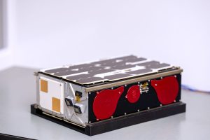
Wolverhampton will receive £1.3m in funding from Ofwat’s Innovation fund. This is to build, launch and operate a fleet of six Low Earth Orbit (LEO) micro satellites. Basically, to help provide intelligent water infrastructure management.
Wolverhampton University
Professor Mohammad Patwary, Director of the University’s Digital Innovation and Solution Centre (DISC), is the Academic Lead on the project. He commented:
“This Ofwat-initiated opportunity marks a major innovation leap for the UK – enhancing the water industry’s efficiency and infrastructure longevity, while creating a platform for critical sectors like energy, transport, and telecom, positioning the UK as a leader in LEO satellite-driven innovation and productivity.”
This project involves collaboration between multiple partners. These consist of: South Staffordshire Water, Quub, University of Wolverhampton, Sutton and Easy Surrey Water, Northumbrian Water, Welsh Water, Southeast Water, Scottish Water, United Utilities and Spring.
The Space Eye project results from a successful application to Ofwat’s Water Breakthrough Challenge 5. This has allocated £40 million to water-sector initiatives
Water loss
According to Water UK, water loss is a persistent issue for the UK water industry, with an estimated 19% of the water supply lost before it reaches consumers.
Traditional detection methods, highlights the unviersity, remain labour-intensive and inefficient. For example, acoustic monitoring and tracer gas detection.
These approaches typically locate fewer than one leak per day per crew, they say. And they will cost between £250 and £2,000 per inspection. In contrast, satellite-based Synthetic Aperture Radar (SAR) and L-band radar (e.g., ASTERRA) improve detection rates. Their high operational costs, however, and image refresh rates of 7–14 days still limit their effectiveness. Hence the search for alternatives.
Aurora
The Space Eye project has the following requirements:
- High-frequency imaging, delivering data every 6 hours
- 2–5 metre per pixel resolution, with the detail for pinpointing leaks.
- Using machine learning to improve accuracy
- Detection costs x10 times lower than current satellite-based methods.
- Scalability beyond the UK
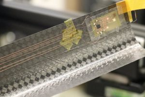
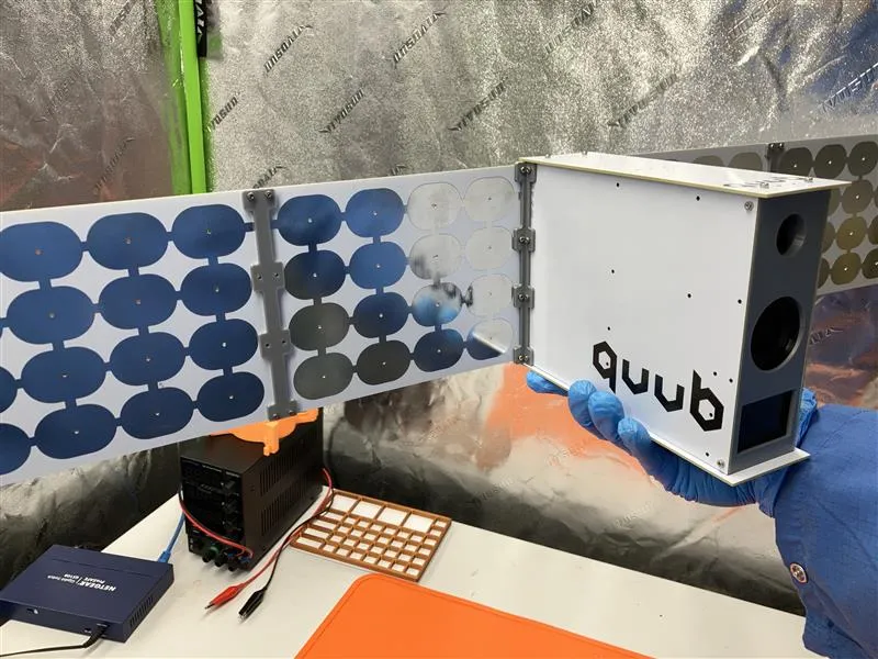
The project will be using the Quub 6P Aurora Bus, which offers the same volume as a 1.5U Cubesat but allows flexibility for non-standard circuit board designs.
The company writes:
“Using Quub’s Custom Microcontroller Boards, Aurora Can Support A Load Of Up To 7 Different Sensor Types, With Up To 26 Watts Of Onboard Power. Our Standard Electro-Optical (EO) Package Starts With A Multispectral (Near-IR To UV) Telescope With Between 5 And 10 Meters Per Pixel Resolution To Support Remote Sensing And Anomaly Detection. This Design Also Supports A Vacuum Arc Thruster For Propulsion, Which Allows The Satellite To Adjust Course, Or To Automatically Deorbit In The Event Of System Failure.”
Quub
Quub itself is a US-based 3D printing microsatellite company. It has an office in the UK – in London – for its Earth Observation business. And it has previoulsy stated that monitoring the UK’s water industries will be one its priorities.
Among the features of Quub, aside from 3D printing components, is its use of the Raspberry Pi for terrestrial testing devices.
Quub satellites comprise 8 ‘pods’ of functionality. The company outlines them as follows:
- Inertial Measurement Unit (IMU): This tells the satellite where it is and how it’s oriented in orbit, somewhat akin to GPS on the ground.
- GPS: This lets the satellite know where it is in relation to the ground below.
- Vacuum Arc Thruster (VAT) engine: This is the satellite’s propulsion system.
- Radio: This transmits data, once gathered, back to Earth.
- Spectroscopy: This instrument measures gas composition of an atmosphere.
- Light Detection and Ranging (LIDAR): This measures altitude and distance using laser pulses.
- Ultrasonics: This is a data communications system used in ground testing. (Note: This system does not have orbital uses.)
- Infrared (IR) camera: This camera collects images of heat levels, rather than visible light.
Images: University of Wolverhampton
See also: Quub microsatellite company launches British subsidiary